The Greenway
  • Home
  • Calendar
  • Things to Do
  • Contact
  • Maps
  • Management
    • GW Technical Committee
    • GW & Trail User Group Notes
  • Forms
  • Greenway Plans
  • Programs
    • Adopt-a-Trail Program
    • Wildlife Management
    • Bench & Tree programs
    • NASA Picture Posts
    • Project Requests
    • Special Events Forms
  • Partner Links
  • FAQ
  • Comments
  • Volunteers - event
  • Riparian Restoration
  • Get involved
  • Flood information
  • 1997 Flood Memories
  • History
  • Photo Submissions
Search by typing & pressing enter

YOUR CART

Desiree Drive & Rivers Edge Project

On February 20, 2024, The Grand Forks City Council approved a project to improve access to an undeveloped portion of The Greenway. This project is located between 47th and 62nd Avenues South, as shown on the map at right.
PROJECT PRESENTATION

A brief history

This area along the river was originally outside of the city limits when the flood protection system was built after the 1997 flood. The neighborhood east of the project was annexed in 2014.  The property is owned by the city and is part of The Greenway, as defined in Grand Forks 14-0402 city code:
Greenway refers to the physical space controlled by the city council generally described as the wet side of the toe of the levee adjacent to the riverbank, excluding areas leased to the park district and flood protection features such as floodwalls, levees, and pump stations. The greenway generally starts at approximately fifty (50) feet north of the centerline of the north pedestrian bridge, north of Riverside Dam, to the centerline of the south end drainway as more particularly shown on appendix A
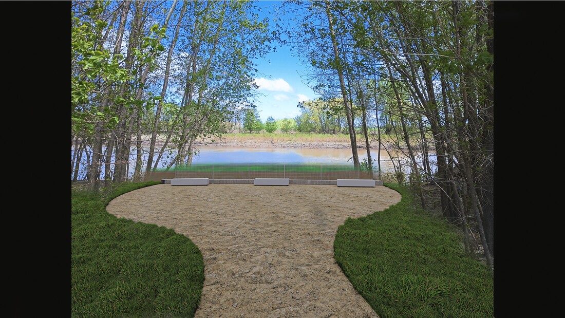
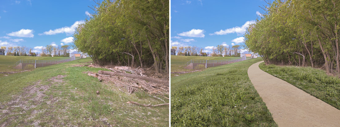
​The property in the project area has been largely undeveloped and residents, both near and far, have discovered the benefits of this quiet, public space. A small clearing on the riverbank at the storm water outfall has become a popular fishing and river viewing area. Unfortunately, this area has also attracted unwanted behaviors and vandalism.

The Goal

The project's goal is to increase accessibility for all ages and abilities and improve the amenities at a popular riverbank fishing area. The remoteness of this location has limited access and awareness of the riverbank opportunities for users outside the adjacent neighborhood. A paved shared-use path and benches for resting will encourage more visitors who have been previously excluded from using the area due to a lack of suitable access and information.
​

What's does this project include?

  • Paved trail from 47th Avenue South to the fishing area
  • Better definition of the existing unpaved trail
  • Clearing a larger area at the fishing site to allow better visibility 
  • Replacing the current metal retention wall at the fishing site with a higher wall​
  • Benches, trash receptacles, and an informational kiosk along the trail and at the fishing area

Funding

Funding has been received from the following sources:
  • ND Outdoor Heritage Fund $155,450
  • Garrison Diversion Conservancy District $50,000
  • Greenway Capital Improvements Fund

What's next?

Spring 2024
  • City staff is working on several applications for potential funding. 
  • KLJ Engineering is working on a building design that can be advertised for bids.
  • Tree removals to open up the area for work will begin later in the season. 
Link
Picture
Click on images to enlarge

Register for Greenway updates

Sign up
Staff Report February 2024
Loading...
[email protected]